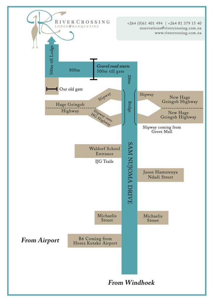
Road Directions from Windhoek City to River Crossing Lodge
Windhoek Central via Sam Nujoma Drive (B6 highway) to St Pauls College – 3.4 km (8 min drive). Continue over the traffic lights on Sam Nujoma Drive for a short distance.
Sam Nujoma Drive will fork. Do not turn left, continue straight. If you turn left on the B6 it will take you out to the Hosea Kutako International Airport.
Drive straight on Sam Nujoma Drive past Michaelis Street situated on your left- and right-hand sides.
Drive past Jason Hamutenya Ndadi Street on your right-hand side and Waldorf School’s entrance & IJG Trails on your left-hand side – 11 km from the Windhoek Central. (You are still on Sam Nujoma Drive)
Continue straight by driving underneath the flyover bridge connecting to the Hage Geingob highway. Do not turn off, continue straight.
The road will eventually become a gravel road, continue for another 500 m to the entrance gate of River Crossing Reserve. The gate will open automatically, pass through the gate and continue for another 800 m until the road makes a right turn and then continue for another 500 m to the parking area and lodge Reception.
Road Directions from and to Hosea Kutako International Airport
From the Airport exit road, turn left on to the A1 – Hage Geingob Highway. Drive for +/- 35 km until you reach the Klein Windhoek offramp, take the offramp which will take you to Sam Nujoma Drive at the bottom of the offramp. Turn left and proceed to the gravel road
And to the entrance gate of the River Crossing reserve. The gate will open automatically. Pass through the gate and continue for another 800 m until the road makes a right turn and continue for another 500 m to the parking area and lodge Reception.
Guests coming from the south and south-west direction must turn off the Aus Road on to the B9 leading into the Hage Geingob A1 highway Continue in an easterly direction for +/- 5 km to the turn off on the left-hand side indicating Klein Windhoek off ramp. Drive to the bottom of the offramp and turn right and continue underneath the bridge to the gravel road and entrance gate of River Crossing reserve.
GPS Coordinates: 22° 36´05.8”S 17° 08´02.2”E
(-22.601600, 17.133947)